
GIS Volunteers Ready to Support Emergencies in Indiana
It is the IGIC GIS Response Corps mission to create an inclusive and representative statewide network of response corps members dedicated to:
- Enhancing accessibility to geospatial applications, technologies, and products which assist Emergency Management Practitioners in their decision making process in the event of an emergency.
- Delineating all-hazards emergency management planning, response and assessment considerations.
- Creating a network for professional exchange and access to technical expertise.
- Encouraging interactions and collaborative initiatives among those conducting Emergency Support.
- Promoting the standardization of methods to increase the access and the value of data among many users.
Objectives
- Provide geospatial support in the event additional GIS resources are required to support emergency related missions across Indiana.
- Identify geospatial personnel, technologies, and products that are appropriate for the emergency event.
- Define processes and recommended data sources and technologies to support response and recovery phases of an emergency event.
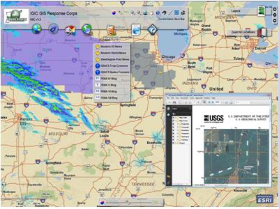
The Corps has 55 committee and sub-committee members. The members are from various parts of the state and include Local, State, Federal, Private and Educational partners. Several accomplishments the corps has completed this year have been the implementation of a GIS web mapping application and the creation of an EOC binder. The web mapping application is displaying data delivered by the scientific and emergency response communities. The binder provides a simple to use reference for GIS analysts to use in an EOC. Both items are a continual work in motion.
More information about the IGIC GIS Response Corps can be found at the following links, http://igic.org/committees/giscorps.html and http://mccullough-consulting.net/IGICResponseCorps/
The Indiana Geographic Information Council (IGIC) is a nonprofit membership organization of GIS users, professionals and educators. Administered by an elected board of directors, IGIC is recognized as the official statewide coordinating body for Indiana geographic information.
0 comments