Emergency helicopter landing zones
One of the ways that my community of Berkeley CA is preparing for disaster is to have all the emergency helicopter landing zones pre-selected and pre-surveyed. We used Google Maps for the preliminary survey, selecting the baseball fields, softball fields, football fields, and large parks as potential helicopter landing zones. We used the GPS coordinates from Google as a first guess, then went to the actual sites, ensured that there were no power lines or trees that would interfere with helicopter operations, and confirmed the GPS coordinates were accurate. In most cases, the landing zones are fenced or otherwise have restricted access, allowing for safe landing operations.
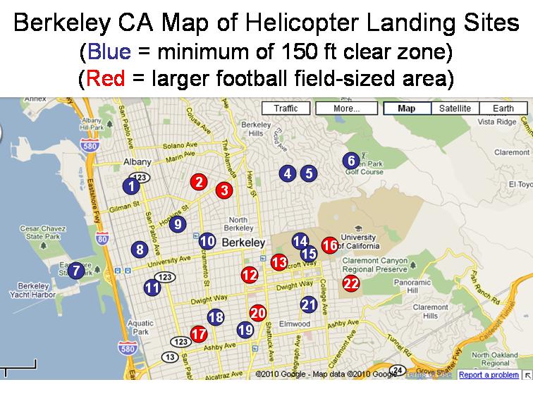
Now we have a list of 22 landing zones, all with a minimum of 150 feet clear zone, and with 8 of those listed as "Large" zones which are the size of a football field. These 8 zones would allow for the larger search and rescue helicopters to land, drop off medical supplies to the CERT teams, and pick up multiple wounded from CERT triage to take to hospitals outside the disaster zone. The smaller zones could handle small and medium sized helicopters for the same purposes in all parts of the city. In some disaster scenarios in urban areas (such as ours), this would be the ONLY way to reach the people and provide critical assistance.
This is something easy to do in advance of any disaster in any part of the country. This list needs to be given to FEMA, the National Guard, and any other organization that would respond to the disaster since communication would be sporadic during the disaster. Each community would be responsible for an annual update of the landing zone list to ensure it is accurate.
I hope you find this suggestion helpful.
Sandy Miarecki, CERT Team Leader, Berkeley CA
0 comments