Implementing A Common Spatial Reference System (US National Grid) - “Location Interoperability”
Sharing the Responsibility to Protect Communities Against the Impacts of Disasters
Implementing A Common Spatial Reference System (US National Grid) - “Location Interoperability”
In order for all sectors of the Emergency Services/Management Enterprise to be fully integrated with a future system for emergency management/services, gathering actionable feedback from social media internet websites, etc., please consider and over the coming few years plan and begin a process for full implementation of the Federal Geographic Data Committee (FGDC) United States National Grid – North American Datum 1983 (USNG-NAD83) standard. The most effective use of location services and technologies such as Global Positioning Systems (GPS) will not be possible without such a standard implemented nationwide.
This common frame of spatial reference is the consensus solution for the need identified in the US Fire Service Needs Assessment report submitted to Congress by USFA/NFPA (01/2003): "The vast majority of (fire) departments with a map coordinate system have only a local system, which means the system they have is unlikely to be usable with global positioning systems (GPS) or familiar to, or easily used by, non-local emergency response partners, such as Urban Search and Rescue Teams, the National Guard, and state or national response forces. Moreover, interoperability of spatial-based information systems, equipment, and procedures will likely be rendered impossible beyond the local community under these circumstances. This reliance almost exclusively on local systems exists across-the-board, in all sizes of communities."
Easy to implement suggestions for “location interoperability” preparedness in your community:
-
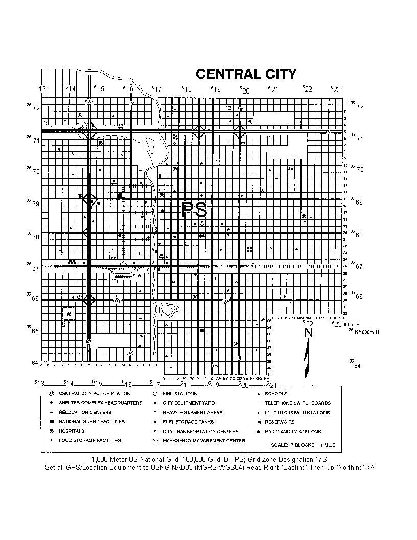
Gridded maps and location devices, paper and digital, are primary tools used in search and rescue operations, disaster response operations, delivery of relief services, and training for these eventualities. It is critical that the same reference system be used in communications protocols, equipment, training, and operations to ensure location interoperability in this map driven enterprise.
-
All responder assets should set their GPS/location technologies to the same reference, USNG-NAD83 (older GPSs use the interoperable Military Grid Reference System (MGRS-NAD83/WGS84)).
-
Access multiple mobile smart phone platform location services apps that already offer USNG (or MGRS) as one of the settings.
-
None of the three non-interoperable versions of latitude and longitude are well suited for large-scale mapping, the reason lat/long is seldom found on city/county level street maps and fewer than 5% of US Fire Departments use them.
-
Publish local maps and indexes with the national grid format. Make these available to response assets, CERT members, the general public as well as public agencies. Include the national grid on any ‘disaster response series’ maps your local government has prepared; enhance existing maps such as call alarm box system maps with a full fine line national grid.
-
Coordinate with your local emergency management officials who may choose to continue to use their own unique reference systems, yet are then prepared for responding outside agencies that are unfamiliar with it.
-
This is a mostly large-scale (<1:24,000) map driven enterprise, paper and digital. Exercise maps related to community security, disaster planning, and training as if there were no street signs and/or non-local assets are unfamiliar with the response area. Practice organized search and rescue activities using USNG to assign search areas and to report results. Include tactical use of USNG in training, i.e. truncation of coordinates for required precision. Stress importance of correct use of the International Phonetic Alphabet for voice communications.
-
Make USNG based geoaddresses (ex. 18SUK06260029) part of the officially recognized identification for parcels and buildings such that it supplements street addresses and is included in official databases. Be aware (beware) of accuracy issues if location source data, such as street address geocoding, is not GPS or survey derived. GIS techniques can automatically determine surveyed existing parcel geoaddresses in a batch process.
-
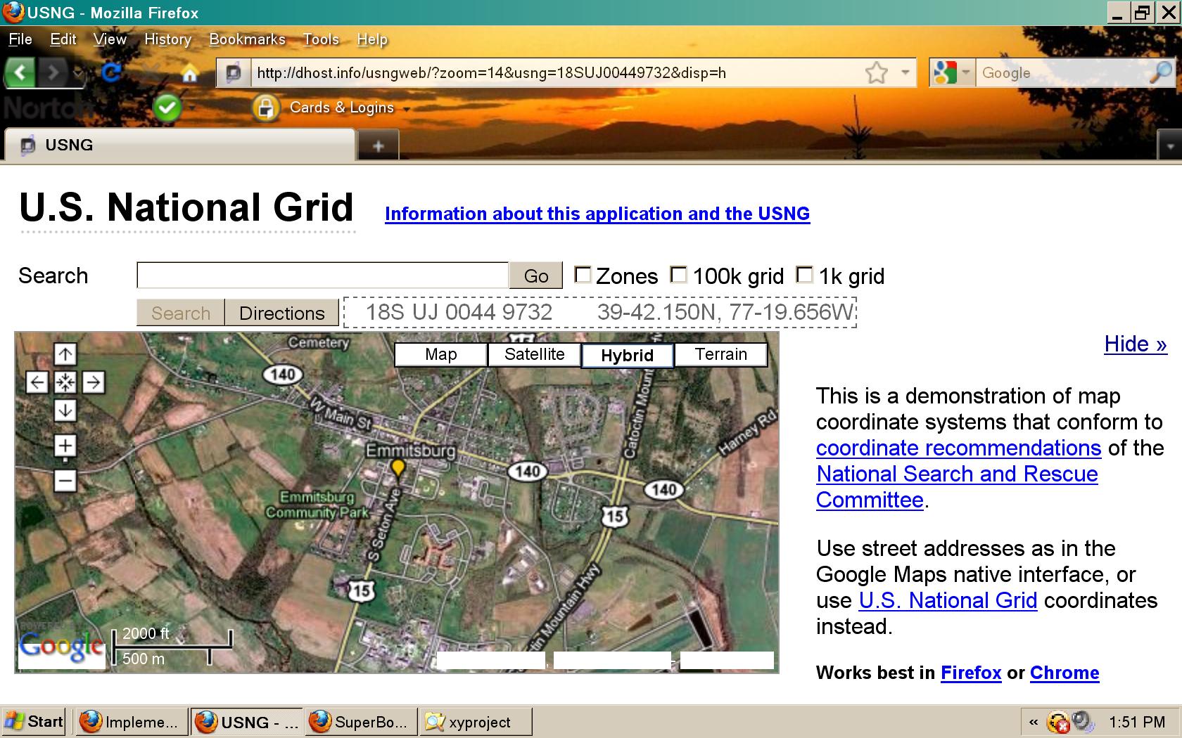
Help educate the general public, CERT members, and your local emergency responders on how to read and use the national grid in a local context. Access the U.S. National Grid (USNG) Demonstration Map of the National Emergency Training Center (NETC) and FEMA's Intro to Standards-Based Geospatial Information Technologies (GIT) and the USNG for easy to use education/training materials. Use web sites like the Federal Geographic Data Committee (http://www.fgdc.gov/usng) for many other resources and examples and Larry Moore's fantastic USNG demonstration website (http://dhost.info/usngweb/?zoom=14&usng=18SUJ2487305993&disp=h) to make it fun and interesting while raising awareness to easy solutions for map-based operational friction (example, in the URL string pointing to the USNG demo site, change the zoom “level=14” to “level=18”; change the grid (geoaddress) to one of your choosing by finding a location on the map and clicking the left mouse button to copy/paste the new grid, or typing in the grid you've just received over the radio like “18SUJ00449732”; change the “disp=h” at th end of the string to “disp=t” or “disp=m”.
-
USNG is available to supplement street addressing, not replace it, and the public should know how to use USNG coordinates for providing the location of their residences or for when they are in a transient/tourist status. It should not matter to them whether their incident occurs in their home on the East Coast (18SUJ0096), or while on vacation in the middle of Wyoming, USNG: 13TBH91856405. In either place they should be able to tell responders where they are and what they need without ambiguity.
-
Challenge the CEO's of Google, Facebook, Twitter, etc., to just simply study the issue (and then implement USNG).
-
Use the USNG geoaddress in your daily activities. Add the geoaddress for the entrance to your building to your business card. Stipulate in statements of work that USNG will be incorporated in products and services, especially for E911 at the user interface. This is a multi-year process better started sooner than later.
-
Emergency plans (emergency/evacuation messaging, ect.) should be updated to include USNG coordinates in addition to street addresses for locations. USNG coordinates serve as the geoaddress to supplement street addresses. Away from the road network or after the street signs are gone (as in Hurricane Andrew), the geoaddress may be the only one available. To this end, use currently available resources such as the National Guard to teach your community responders and disaster workers how to use USNG map products, though many having military experience will already be familiar with the format. Search the Internet for "USNG Florida" or "USNG Minnesota" for many excellent resources and examples of USNG usage (statewide mutual aid plans, street/trail signage, ect...overview on the USNG from Minnesota. (PPT)).
"The U.S. National Grid is the established standard for all operations that involve the communication of location between humans and between humans and electronic devices, (e.g., GPS, GIS) and humans and maps." (Richard Hogan, USGS)
0 comments